

An Assessment of the USGS ShakeAlert Earthquake Early Warning System
An Assessment of the USGS ShakeAlert Earthquake Early Warning System

By: KRISTIAN TREY KODMAN
Fall 2021 (MLA Format)

Sections:
ShakeAlert assessment
Introduction
How ShakeAlert works
ShakeAlert warning delivery
How effective has ShakeAlert been?
Do alerts create sufficient safety?
What improvements became implemented after rollout?
Conclusion
Figures
Cover- https://www.shakealert.org/ShakeAlert_Delivery_Slide.png
How ShakeAlert works- https://www.shakealert.org/ShakeAlert_Block_Diagram.jpg
ShakeAlert delivery- https://www.shakealert.org/ShakeAlert_V2_0_slide.png
Acronyms
EEW - Earthquake Early Warning
EPIC - Earthquake Point-Source Integrated Code
FEMA - Federal Emergency Management Agency
FinDer - Finite Fault Rupture Detector
SCSN - Southern California Seismic Network
USGS - United States Geological Survey
WEA - Wireless Emergency Alert System
1.1 Introduction
This research report will cover the assessment of evidence relating to the effectiveness of the ShakeAlert earthquake alert system now fully operating across California, Oregon, and Washington. Since full rollout in California in 2020 after months of testing in specific regions of the state, rollouts in Oregon and Washington have occurred in 2021.
With very few seismic events above the necessary magnitude of 5.0 for public alert since these rollouts, the evidence from earthquakes during the testing phase will get analyzed. Look for how effective the system was for those with the prototype alert system ready to activate personal safety protocols. Also, from these results, the officials’ methods in alerting the general public beyond an installed device application and its conflict of usability for the alert receivers.
A further question from this research is whether or not the ShakeAlert system is worth its investment. Expecting earthquakes when living in a region prone to infrequent devastating seismic activity versus knowing only a handful of seconds when one occurs to prepare quickly during that panic is what must get weighed. How does knowing an earthquake is coming help an individual make the best decisions possible in that short amount of time?
Geologists, scientists, and earthquake enthusiasts prepared to take this compilation of scientific findings and make their conclusions is welcome. Relaying the initial real-time results during ShakeAlert messages from actual seismic activity and how it relates to citizens on the ground during the natural event progresses the study of the next batch of data and conclusions when an earthquake occurs.
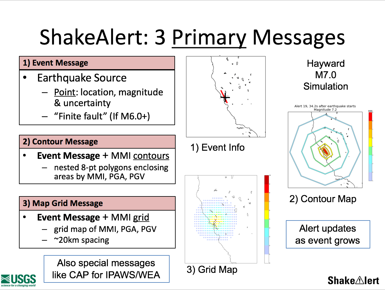
1.2 How ShakeAlert works
The U.S. West Coast’s ShakeAlert EEW (Earthquake Early Warning) System became fully functional with tests beginning Phase 1 of alerting in California, Oregon, and Washington in October 2018. Partners such as FEMA, cellular carriers, mass notification companies, and others provide public alerting for this mass alert system that detects significant earthquakes so alerts can reach citizens before the shaking hits. ShakeAlert is not an earthquake prediction system. Instead, a digital message gets delivered that indicates an earthquake has begun and shaking is imminent. Live alerts were sent to “beta” users in California since January of 2012 and in the Pacific Northwest since February of 2015 (ShakeAlert.org).
The USGS (U.S. Geological Survey) with State and university partners have begun Phase 3 on the U.S. West Coast in 2021. Utilizing ShakeAlert now are utilities, hospitals, transportation systems, and educational settings with more to join. Beyond Phase 3, the USGS with its partners will continue to coordinate with official agencies in California, Oregon, and Washington (ShakeAlert.org).

Identifying an earthquake nearly immediately after it begins, calculating the intensity of shaking that will result, and sending alerts to people and infrastructure in harm’s way is the system’s goal. The primary (P) wave energy, which rarely causes damage, is detected as the first energy radiating from an earthquake. P-waves allow estimates of the location and the magnitude. This method provides a warning before the Secondary (S)-wave that causes much more damage (ShakeAlert.org).
1.3. ShakeAlert warning delivery
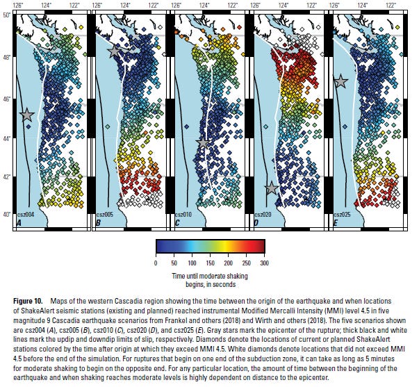
Within the next 30 years, California has a 99.7% chance of a magnitude 6.7 or larger earthquake, while the Pacific Northwest has a 10% chance of a magnitude 8 to 9 megathrust earthquake on the Cascadia subduction zone (ShakeAlert.org).
Studies in California, Oregon, and Washington show warning times range from a few seconds to tens of seconds. The warning allows time to slow trains and taxiing planes, prevent cars from entering bridges and tunnels, move away from dangerous machines or chemicals in work environments, take cover under a desk, or automatically shut down and isolate industrial systems (ShakeAlert.org).
The USGS began testing public notification in California in October of 2019 through the WEA (Wireless Emergency Alert System) and cell phone apps. ShakeAlert expanded the testing of public alerting to mobile devices to Oregon in March 2021 and Washington in May 2021 (ShakeAlert.org).
Also, GOOGLE launched a new, free smartphone feature known as the Android Earthquake Alerts System, available globally. To see if the alerts are on in an Android device, go to Settings > Location > Advanced > Earthquake Alerts (Business World Online).
However, the region near the epicenter is where alerts will not arrive before shaking begins. The ShakeAlert system needs time to detect the earthquake, issue a warning, and for USGS partners to distribute the alert (ShakeAlert.org).
Large earthquakes can take tens of seconds or more to rupture along a long fault, and ShakeAlert attempts to track this growth, causing the predicted ground motions to update over seconds to tens of seconds or even minutes in a great earthquake (McGuire, Jeffrey J., et al., 7).
1.4. How effective has ShakeAlert been?
The ShakeAlert earthquake early warning system detected an Mw 6.4 earthquake on the morning of 4 July (10:30 a.m. PST, 20:30 UTC) 2019 near Ridgecrest and alerted in 6.9 seconds. It was the most significant event inside the SCSN (Southern California Seismic Network) in 20 years. A more significant Mw 7.1 event followed 31 hours later (5 July, 8:19 p.m. PST; 6 July, 03:19UTC), some 200 seconds after an Mw 5.1 foreshock. An active aftershock sequence followed, with multiple Mw 5 events in the first few days. Besides shaking southern California, these events were the first full-scale readiness test of the SCSN for EEW before the October 2019 rollout ShakeAlert system (Stubailo, Igor, et al., 170).
Regional network operations performed well throughout, and performance during the most significant events in the Ridgecrest sequence brought to light several aspects in which SCSN could strengthen the telemetry system to improve low-latency data delivery to ShakeAlert (Stubailo, Igor, et al., 185).
The 2020 Mw 5.8 Lone Pine earthquake, the largest earthquake on the Owens Valley fault zone, eastern California, ruptured an extensional stepover in that fault since the nineteenth century. Comparing background seismicity and 2020 Ridgecrest aftershock rates showed that this earthquake was not an aftershock of the Ridgecrest mainshock (Hauksson, Egill, et al., 679).
ShakeAlert created the first alert for this earthquake at 9.9 seconds after the origin time with an initial magnitude estimate of Mw 5.0 and an initial location error of just 0.98 km (Hauksson, Egill, et al., 692).
At the Lone Pine earthquake, ShakeAlert was in public testing in California, which had just begun in October 2019. People near the Lone Pine earthquake received alerts via two main distribution channels: smartphone applications (MyShake, QuakeAlert USA) and the IPAWS (Integrated Public Alerting System) via WEAs (Hauksson, Egill, et al., 693). The technical issues with IPAWS caused the WEA ShakeAlert updates to get broadcast over several minutes, with people receiving multiple alerts on their WEA compatible mobile phones (Hauksson, Egill, et al., 694).
Quick communication is critical for people to continue developing trust in the system, as evidenced by the Hawai‘i false ballistic missile alert in 2018, so templated post-alert messages via the ShakeAlert Twitter from the USGS got designed to explain to people what occurred with the system and what to do next (Hauksson, Egill, et al., 694).
1.5. Do alerts create sufficient safety?
Successful development and operation of a robust EEWS like ShakeAlert require significant investments in technology and infrastructure. Covering such high costs requires public funding, at least partially if not entirely, for which reason consensus and support are indispensable. At the same time, the goal of EEWS is to facilitate protective behavior and enable automated responses when strong shaking becomes expected. Therefore, a better understanding of how society and individuals perceive the system and how they react to alerts is crucial to maximizing the benefits of earthquake hazard mitigation (Ahn, Alicia YE, et al., 2).
1.6 What improvements became implemented after rollout?
Since 2018, the implementation of ShakeAlert combines two network-based algorithms, including EPIC (Earthquake Point-Source Integrated Code) and FinDer (Finite Fault Rupture Detector), to utilize the capability of the source-based EEW approach to the maximum extent. ShakeAlert strikes a balance between the timeliness of alerts for near-source targets in small magnitude events and the accuracy of warnings for the natural evolution of occurring rupture in case of significant magnitude events. Additionally, ShakeAlert is also underway to incorporate geodetic EEW algorithms into the production system. Combination of ElarmS with geodetic algorithm (e.g., G-larmS, BEFORES) from geodetic and seismic measurements will achieve mutual advantages on achieving timeliness in event detection and also accuracy in magnitude estimation, even though realistic expectations from geodetic approaches in risk investigation from technical perspectives (Huang, Wei, 17)
A primary goal in developing ShakeAlert is to minimize computational cost and processing time between when an earthquake is detected and when an alert gets sent out without compromising accuracy. One way of doing this is to reduce the number of variables that system algorithms must calculate. Both algorithms have a configuration to assume that all earthquake types occur at fixed shallow depths, reducing searching for the source location from a 3D to a 2D problem (Thompson, Mika, J. Renate Hartog, and Erin A. Wirth., 1).
If data gets returned in a first-in, first-out model, the only way to avoid data latency for EEW is to ensure the telemetry bandwidth is high enough to prevent data delays. The Ridgecrest experience shows that telemetry links can operate for days with minimal latencies during periods of low-to-moderate seismicity yet to be challenged to support low-latency data delivery during significant events. To improve latency performance during events in the future, SCSN is implementing improvements to weak radio links, reducing the emphasis on the cellular system, and expanding reliance on high-bandwidth radio connections directly to backhaul telemetry systems (Stubailo, Igor, et al., 185).
1.7. Conclusion
While the Pacific Northwest and California have not yet had a massive quake, the Ridgecrest and Lone Pine earthquakes demonstrate the efficacy of the ShakeAlert system for preserving public safety. The collection of that data also led to improved algorithmic and alert relay systems concerning the quake’s size and range of alerts to citizens from the quickly computed magnitude prediction and location.
Works Cited
Ahn, Alicia YE, et al. "Perception of earthquake risks and disaster prevention awareness: A comparison of resident surveys in Sendai, Japan and Seattle, WA, USA." International Journal of Disaster Risk Reduction 66 (2021): 102624.
Business World Online. “Google launches Android Earthquake Alerts System” June 17, 2021. https://www.bworldonline.com/google-launches-android-earthquake-alerts-system/.
Hauksson, Egill, et al. "The Normal‐Faulting 2020 M w 5.8 Lone Pine, Eastern California, Earthquake Sequence." Seismological Society of America 92.2A (2021): 679-698.
Huang, Wei. "Retrospective Study of FinDer Algorithm During the 2019, Ridgecrest Earthquake Sequence." (2021).
McGuire, Jeffrey J., et al. Expected warning times from the ShakeAlert earthquake early warning system for earthquakes in the Pacific Northwest. No. 2021-1026. US Geological Survey, 2021.
“Shakealert: An Earthquake Early Warning System for the West Coast of the United States.” ShakeAlert®, https://www.shakealert.org/.
Stubailo, Igor, et al. "Latency of Waveform Data Delivery from the Southern California Seismic Network during the 2019 Ridgecrest Earthquake Sequence and Its Effect on ShakeAlert." Seismological Society of America 92.1 (2021): 170-186.
Thompson, Mika, J. Renate Hartog, and Erin A. Wirth. "Effect of Fixing Earthquake Depth in ShakeAlert Algorithms on Performance for Intraslab Earthquakes." Seismological Research Letters (2021).